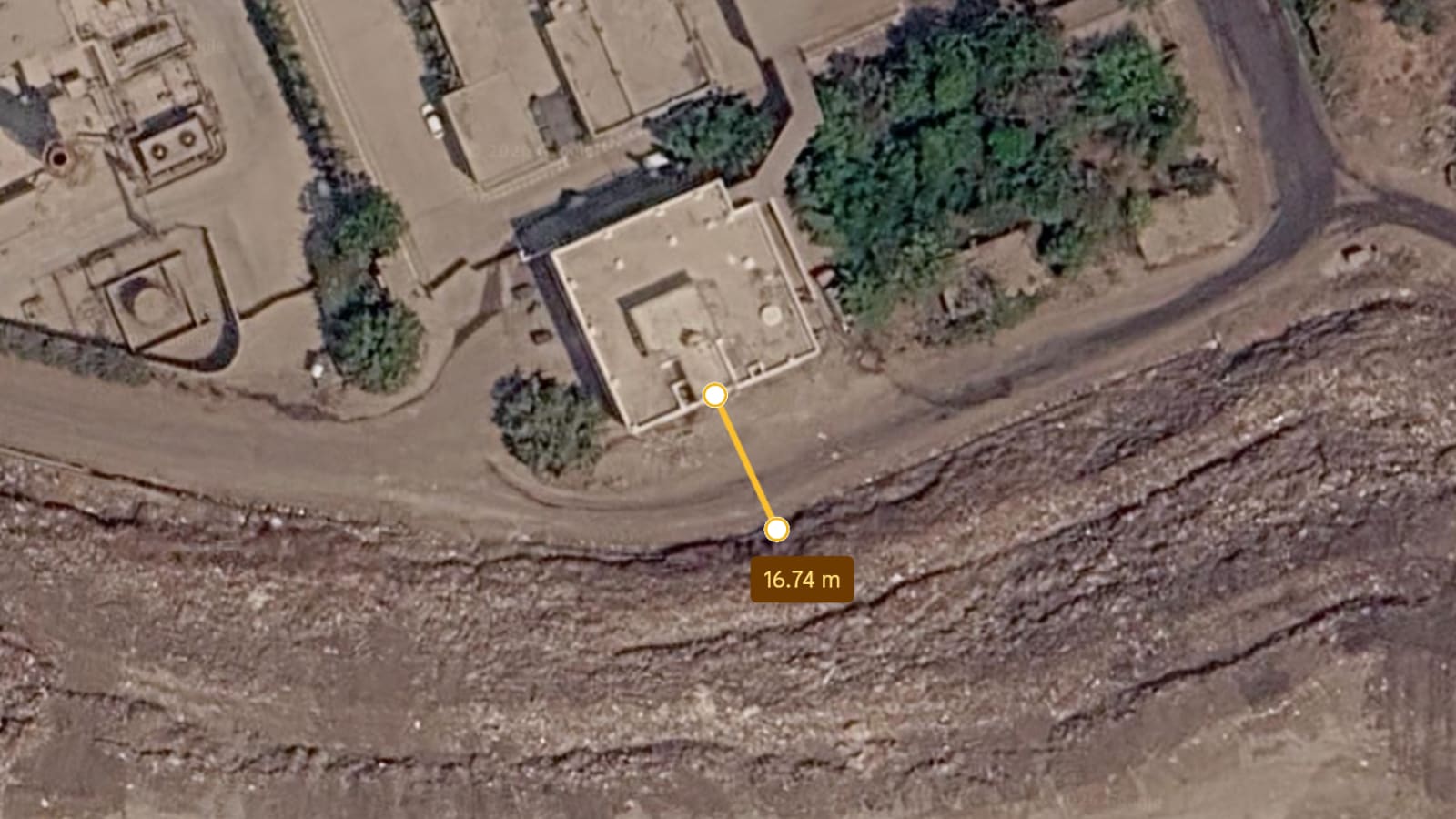
Pune landslide: Satellite image shows office to garbage mound distance was 16 metres and not 30
Source Entity
Soham Shah
Intelligence Synthesis
AI-Generated Core Insights
Satellite imagery from Google Earth has revealed that the distance between an office building and a garbage mound involved in a Pune landslide was only 16-17 meters, contradicting previous claims that the distance was 30 meters.
Forensic Spatial Analysis of the Pune Landslide
Recent revelations regarding a landslide in Pune have shifted the focus from the natural disaster itself to the potential human error and administrative negligence that preceded it. The core of the current controversy lies in the precise spatial relationship between a commercial office building and a nearby garbage mound. While initial reports or official claims suggested a buffer zone of approximately 30 meters, new evidence derived from Google Earth satellite imagery indicates that the actual distance was significantly shorter—measured at only 16 to 17 meters. This discrepancy is not merely a matter of numerical correction but a critical piece of evidence in determining the liability and the level of risk the building's occupants were exposed to.
The Significance of the 16-Meter Gap
In the context of geotechnical stability and urban safety, the difference between 30 meters and 16 meters is profound. A 30-meter buffer might have provided a marginal safety margin against slope failure, whereas a 16-meter gap places the structure almost directly within the immediate failure zone of an unstable waste mound. Garbage mounds, particularly those that are unmanaged or illegally dumped, lack the structural integrity of natural hillsides. When saturated by heavy rainfall—a common occurrence in the Pune region—these mounds can undergo rapid liquefaction or slope collapse. The proximity of the office building suggests that the structure was built in an area of extreme vulnerability, likely ignoring standard zoning laws or safety setbacks required for hazardous waste sites.
Role of Remote Sensing in Disaster Accountability
This case highlights the increasing importance of satellite imagery and Geographic Information Systems (GIS) in forensic disaster analysis. By utilizing Google Earth imagery from March, investigators were able to bypass potentially skewed ground reports and obtain an objective, timestamped view of the site. This transition toward "digital evidence" allows for a higher degree of transparency and accountability. In many urban landslide cases, physical evidence is often swept away or altered by the disaster itself; however, historical satellite data provides a permanent record of the landscape, making it nearly impossible for authorities or developers to misrepresent the pre-disaster conditions of the site.
Urban Planning Failures and Environmental Risks
Beyond the specific measurements, this event underscores a broader systemic failure in Pune's urban planning and waste management. The existence of a garbage mound in such close proximity to a functional office building points to a lapse in municipal oversight. In rapidly expanding Indian cities, the pressure for commercial real estate often leads to the encroachment of "no-build zones." When waste disposal sites are allowed to grow unchecked near infrastructure, the result is a ticking time bomb. The Pune landslide serves as a stark reminder that inadequate waste management is not just an environmental issue but a direct threat to life and property, especially when combined with the volatile topography of the Western Ghats region.
Legal Implications and Future Safety Trends
Moving forward, the revelation that the buffer distance was halved is likely to have severe legal ramifications. It provides a clear path for negligence claims against the municipal corporation or the developers who approved the building's construction. We can predict a trend where city administrations will be forced to conduct comprehensive "risk mapping" using similar satellite technology to identify other high-risk structures near unstable slopes or waste dumps. The integration of real-time satellite monitoring and AI-driven slope stability analysis will likely become a requirement for urban development in landslide-prone zones to prevent similar tragedies.
Conclusion
In summary, the correction of the distance from 30 meters to 16 meters transforms the Pune landslide from a perceived accident into a case of avoidable risk. The use of satellite imagery has stripped away the ambiguity, revealing a dangerous lack of spatial planning. This event emphasizes the need for strict adherence to building codes and the urgent necessity of clearing hazardous waste mounds from urban peripheries to ensure the safety of commercial and residential infrastructures.